
Last month I had the good fortune to join two friends on a three day cruise, circumnavigating Harstine Island, in south Puget Sound. Normally, trips like these are all about the natural experience, the beauty, the peace, the near death moments, like my trip to Sucia last year.
But this trip ended up being much more about the friends I was traveling with, and let’s face it, their boats. They were both in sail and oar boats designed by Iain Oughtred. And I was very keen to see how they compared to my little sail oar boat, although I knew setting out that there was really no comparison.
One boat was an Artic Tern, belonging to my friend Bruce, who has soloed it the length of the Inside Passage (read his entertaining stories here). And the other was a Ness Yawl, built and crewed by my talented new friend Dan. They are very similar boats, one 18′ in length, the other 19′, with nearly identical beams, 62″ and 64″, and designed to weigh between 240 to 260 pounds. They both sport lug yawl rigs, and both are drop dead gorgeous boats.
For many, Iain Oughtred’s designs represent the very best sail and oar camp cruising boats you can build and use. To my eye they are the most beautiful of the type, and are known to be capable of handling challenging ocean conditions, while not being too heavy. Pulling all of that off is some trick, because designing a small boat that can both row and sail well is challenging. The ideal hull shapes for each are rather dissimilar.
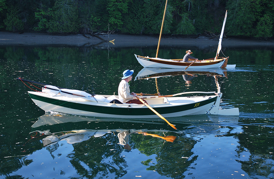
By quick comparison, my modified CLC Skerry is 15′ long, has a 54″ beam, and weighs about 125 lbs empty. And this is one of those situations that shows you how just a little bit of extra length and beam in a similar shaped hull quickly turns into a much more substantial boat, with all the associated pros and cons. My boat Joy appeared a bit toy-like next to theirs, and could handily fit inside theirs. You can sort of get a sense of that from the picture below, taken by Bruce.

Where Did We Go?

Before we get into the more interesting stuff of talking about sail/oar boat sizes, let’s get this rundown of where we went and what we experienced out of the way.
Our little trio of sail and oar boats traveled about 32 miles, over two and a half days, circumnavigating Harstine Island clockwise. Harstine is ten miles north of Olympia, in south Puget Sound, and is not too big, just ten miles long and three wide. So it was no great effort to get around it.
We had planned on venturing further, but had a serious lack of wind the first two days. And it was stupid hot for this early in the year, with temperatures in the high 80’s to low 90s. By the way, did you know that if you varnish yourself with seven or eight consecutive layers of sunscreen you can achieve a superior state of weather protection?
Day 1
A couple of us launched at Arcadia, close to Shelton, and the third from a ramp more to the east (I never learned where), and met up on the east side of Hope Island. We then rowed up the west side of Squaxin Island, and continued up Pickering Passage. We had a good strong current moving with us up the side of Harstine Island. So much so that we really did not need to row, and at times just sat round chatting as the shore passed by. At one point we were almost in a circle. I grabbed my camera to take a picture of their beautiful boats, and laughed to find we were all a bunch of circle jerks, each with a camera in hand.

Eventually we ended up in Jarrell Cove State Park. We stretched our legs on shore, used the facilities, and then tucked ourselves back behind the park dock, in very shallow water. After rafting up for a social dinner, we separated for a glassy calm night on the hook, with a big tide rise called for.
In the middle of the night I woke up to a soft banging on my boat. Peaking out of my tent I was surprised to see I had drifted nearly under the state dock. Turns out I had not put out enough anchor line, and the rising tide had floated my anchor. Stupid of me, but no harm done, and a good lesson; one that I thought I had already learned years ago. The upside of the incident was rowing back into position through a bioluminescent light show with every oar stroke.

Day 2
The next morning we rowed up around the north tip of Harstine, and hung out for nearly an hour on the water at Dougall Point, hoping for wind. Dan and I snacked and chatted a bit, while Bruce did some sketching. But no luck with the wind.

So we continued to row down to McMicken Island State Park, with a short stretch of sailing. We hung out in the shade at the park there for a number of hours. The tide was dropping some 14 feet that day, and Dan and I had to regularly reposition our boats just offshore, using anchor buddies (giant bungee cords). Bruce anchored out and bummed a ride to shore in a dinghy from another sailing family. Note if you visit here that there is a bunch of Poison Oak along the shoreline at McMicken. Fortunately Bruce recognized it before any of us touched it.
It was here that a woman off another boat gave Bruce a very expensive block of truffle cheese. Odd. Pity cheese, you might suspect? For surely these thin, ripe gentlemen must be starving, having rowed from the horizon to this sandy shore, on a blistering hot day? No, not pity cheese. Tribute cheese, we elected to believe. For we three bold adventurers, in our motorless wood boats crafted with our own hands, must cut quite a spectacle of virility, compared to the weak chinned specimens available, that arrived through a haze of sensory corruption, aboard floating motor homes made of frozen-snot, through no effort of mind or body or skill. OK, it was probably pity cheese. It was damn good pity cheese, thrown on a cracker with some smoked Salmon Dan shared.


We had intended to stay the night, but in the afternoon a nice wind came up from the northeast that was too enticing not to use. So we headed off, and crossed the sand bar between McMicken Island and Harstine, with just a few inches of water below our keels, and sailed south down Case Inlet.


Typical though, the wind mostly died a short time later, and I started to row again, to get around Wilson Point. The other two boats were further out in the channel and had put a bit of distance on me. We were headed for Henderson Inlet. The wind came up a little again and I sailed crossed the channel to Henderson. My travel companions selected a more eastern approach, closer to Johnson Point, and seemed to run out of wind for awhile, and I gained a little ground on them. And around the time the wind died for me again, they got too much wind. I was rowing, they were swearing.
Despite our different boat sizes and routes, we all ended up arriving at nearly the same time. We were fairly tired at this point and opted to anchor just behind Dickenson Point. That was probably a mistake, because for the first half of the night we had rolling waves that made for little sleep. My rudder was constantly clunking, which had me fretting about stronger attachments, with closer tolerances. We probably should have continued on down into Woodard Creek for better rest.

Day 3
The next morning the weather report was not good. It was already blowing a steady 10 knots, and was calling for gusts from 20 to 30 later in the day. So we cut out early. Dan sailed off, and took a long time short tacking his way north until he rounded Johnson Point, heading east. Bruce and I opted to row against the wind and then continued to row mostly downwind through Danna Passage to the west. Not long into our row Dan contacted us on the radio and recommended drysuits and reefed sails, because he was experiencing some very gusty conditions. I was already in my drysuit. But we tucked into Big Fishtrap Inlet, and did put a reef in, while checking out the many Sand Dollars in the shallows. We still ended up rowing across Danna Passage, to Brisco Point, because the wind was very gusty.

At that point I got fooled into thinking the breeze had stabilized. So I put up a reefed sail, only to take it down very shortly after. The wind was still stubbornly gusty. I would go from barely moving, to white knuckling the tiller, as my double ended dinghy started surfing, an unnatural activity for her. As we entered Squaxin Passage, and headed north around Hope Island, the wind became even stronger. We ended up crossing Pickinger Passage to our ramp in a steady 10-15 knot wind, that was mixed with stronger gusts. With conditions forecast to get windier, we called it an early day, and pulled our boats out at Arcadia. I had a beautiful drive up the Hood Canal on my way home to Port Townsend.
Here are a few final parting pictures from the trip.


Note: This article originally had a long bit about my thoughts on sail/oar boats. I removed that section because of changes I am making to the focus on this website.
Comments or questions? Click here.
Get on the mailing list to receive notice of new posts here.
Sharing?
Please do share this webpage URL anywhere you like. Do not copy any pictures or content though, unless you enjoy copyright lawsuits.